3D
Relief anomalies (micro-reliefs), as indicators of the possible presence of archaeological remains, is one of the elements sought during archaeological prospecting. In high-altitude environments, where the vegetation cover is low and dense, lasergrammetry and/or photogrammetry can be used for this purpose.
Photogrammetry
From the 2000s onwards, with the development of photography and the computing power of the civilian computers renew the practice of photogrammetry. The automation of and the development of ergonomic software to allow for the image matching by dense correlation was a real highlight for the developpement of this technology (Pierrot-Deseilligny & Pierrot-Deseilligny & Pierrot-Deseilligny & Pierrot-Deseilligny & Pierrot-Deseilligny, Clery, 2011) Image matching by dense correlation enables to obtain a 3D model automatically from a digital image without camera calibration. It is the creation of the detectors Harris (Harris & Stephens, 1988) and SIFT (Lowe, 1999) which is at the origin of its development. These two types of algorithm allow the matching of homologous points, i.e. points present on several shots taken from different points of view different. (Fig. )
It is the shooting distance and the quality of the camera's sensor photo used which gives the quality of the 3D model obtained.
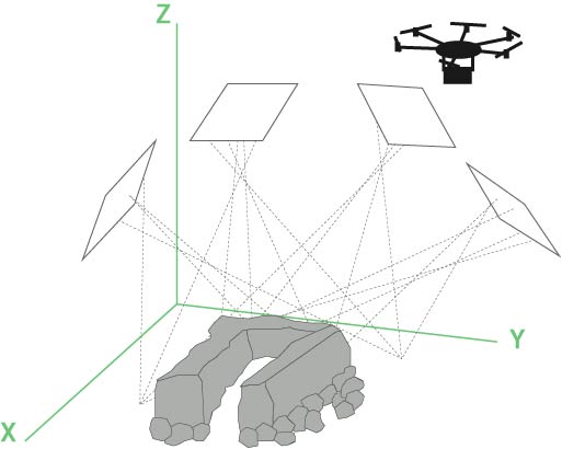
Figure 50 - Photogrammetry by UAV
La solidité des modèles produits repose sur la redondance des images. Ces dernières doivent montrer un très fort recouvrement (80%).
The solidity of the models produced by photogrammetry is based on the redundancy of the images. The images must show a very high degree of overlap (80%).
The creation of Digital Terrain Models (DTMs) by photogrammetry makes it possible to work on the detection of micro-reliefs using different types of processing such as multidirectional shading, Skyview Factor, roughness calculation, Simple Local Relief Model, etc....
Lasergrammetry (Lidar)
Lasergrammetry from aircraft is used from the the 2000s in archaeology, and its reliability is no longer to be proven. (Georges-Leroy, Bock, Dambrine, & Dupouey, 2011; Florez, et al., 2013 ; Toumazet J.-P. , Vautier, Roussel, Rassat, & Doustreyssier, 2016 ; Toumazet J.-P. Vautier, Roussel, & Dousteyssier, 2017). However, this This type of acquisition is expensive, about 15 000 € per km² and cannot be only concern large wooded areas (Fig. ).
The principle of lasergrammetric acquisition is based on the measurement of the time between the emission of a laser beam from the vector (aircraft, helicopter or drone) and its reception. This makes it possible to calculate the distance between source and target. Since the emission angle of the beam is known, it is then possible to know the position of the beam each point.
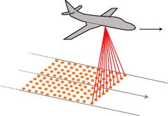
Figure 48 - Principle of airborne lasergrammetry acquisition by aeroplane
The research team working on the Puy-de-Dôme (Toumazet, Vautier, Roussel, & Dousteyssier, 2017) has developed, from Lidar data acquired by aircraft, an automatic extraction procedure characteristics corresponding to agro-pastoral structures, which are characterised by a very simple shape (a circular structure with a which access is via a corridor) and very \"standardised\". In this case, the classic use of shading was not carried out because of the shadows introduce a position error and an error in the deformation of the morphology of the structures.
Their work was oriented towards the matching of models and on a object-oriented classification. The method implemented is effective. It has made it possible to identify 91% of the archaeological structures presenting on the study area. The archaeological structures that have not been identified (7% of the corpus) correspond, either to very eroded, either at places where the algorithm has grouped 2 structures together very close. 25% of the structures identified are abusives detections (Toumazet J.-P. , Vautier, Roussel, Rassat, & Doustreyssier, 2016; Florez, et al. 2014; Toumazet j.-p. , Vautier, Roussel, & Dousteyssier, 2017).
Within the framework of the TAHMM programme, the use of lasergrammetry airborne is not foreseen. First of all because the study sites are only very sparsely wooded and on the other hand the cost of an acquisition cannot be financed. Lasergrammetry by UAVs will, however, be used to attempt to acquire data from the especially in the parts covered with low vegetation of type rhododendron. (Fig. )
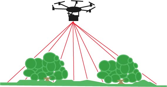
Figure 49 - Principle lasergrammetric acquisition by drone